Getting to Mt Bevin is pretty easy. Start at Invercargill in southern New Zealand and take a 3,000 km boat journey south along the 170° line of longitude until you reach Cape Adare, and from there continue just a little further south into Moubray Bay. Once off the boat and on the ice, just head up Ironside Glacier for 40 kms or so, and just before the end of the glacier turn right where Mt Bevin should be visible up the valley. If ice and weather conditions are favorable, then the summit of Mt Bevin will be only a few more days climb away. Probably worth mentioning that the crevasses on Ironside Glacier are quite severe. In fact, Sir Edmund Hillary and his seasoned expedition team decided it was “impossible” and on their return reported that the “crevasses and icefalls made it a veritable hell of ice”. So if you are planning to go to Mt Bevin, you might want to go the long way around!
The mountain was only named in 2004 by the Advisory Committee on Antarctic Names which is part of the United States Board on Geographic Names and the U.S. Geological Survey. The official description of the name is:
A prominent sharply pointed mountain which rises to 3490 m at the W side of the head of Murray Glacier in the Admiralty Mountains, Victoria Land. The mountain stands 2 mi WNW of Mount Sabine. Named by Advisory Committee on Antarctic Names (US-ACAN) (2004) after Anthony (Tony) J. Bevin, Surveyor-General, New Zealand, and Chairman, New Zealand Geographic Board, 1996-2004, with responsibility for New Zealand surveying and place naming in Antarctica.[1]
It was not long after the mountain was named that members of Tony’s family started thinking about a visit. However the mountain is located in a relatively unexplored region of the Admiralty Mountains, so not much is known about it, making a visit tricky. The following is known:
In January 1841 Captain James Ross first sighted and then named the Admiralty Mountains, but it was not until The International Geophysical Year (IGY), 1957-1958, that anyone explored the interior of the mountain range. The first explorers were a New Zealand geological party of four geologists, three surveyors and a stores officer. This experienced mountain crew departed from Hallett Station and man-hauled up the Tucker Glacier, bagging a few peaks as part of their science and surveying work[2]. They would not have been able to see Mt Bevin from the Tucker Glacier which, at its closest point, would have been at least 30 kms away and obscured by two mountain ranges. In 1961-1962 the U.S. Geological Survey (USGS) Topo North Survey team conducted a survey of the Admiralty Mountains using two helicopters to place ground control stations, a process of setting a tablet or benchmark in the bedrock. It is likely on the 11th of January 1962 the last ground control station of the Topo North effort was set on top of Mt Von Braun which is less than 10 kms from Mt Bevin. As the survey team had looked north-west they would have seen Mt Bevin in the distance.
There have been two mountaineering expeditions in the Admiralty mountains[3]. The first was led by Sir Edmund Hillary in 1967 with a successful summit of Mt Herschel and a traverse to within sight of Robertson Bay and back. The second was led by Greg Mortimer in 1988 with a successful summit of Mt Minto. Both Mt Herschel and Mt Minto are approximately 30 kms away from Mt Bevin and it is unlikely either expedition would have seen Mt Bevin.
The above exploration in the 50’s, 60’s and 80’s has provided virtually no information on Mt Bevin except of course its location and height. In 2004 the Advisory Committee on Antarctic Names was kind enough to provide a name and short description. The official record places Mt Bevin at 71.9° South and 169.45° East and at a height of 3,490 meters.
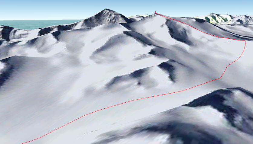
Modern day satellite imagery provides very useful geographical information on Mt Bevin and the surrounding area. Much of the planning for the expedition will be based on satellite and aerial imagery. The graphical representation below is from Google Earth and shows a possible route to the summit of Mt Bevin. The peak to the left and slightly back is Mt Sabine and the large peak on the right in the far distance with a yellow tinge is Mt Herschel. In the top left corner is Moubray Bay.
[1] Geographic Names Information System, U.S. Geological Survey.
[2] The Roof at the bottom of the world: discovering the Transantarctic Mountains, by Edmund Stump, ISBN 978-0-300-17197-9, page 213
[3] Mountaineering in Antarctica: Climbing in the Frozen South, by Damien Gilden, ISBN 978-2-875323-006-5, pages 139-141.